Physical Address
304 North Cardinal St.
Dorchester Center, MA 02124

Would you like to learn more about GIS Training in Nepal? Let’s get started
GIS stands for Geographical Information System. All types of data can be created, managed, analyzed, and mapped with this system. With a GIS, data is connected to a map, combining location (where things are) with descriptive information (how they look).
In nearly every industry and field of science, this provides the foundation for mapping and analysis. It helps users to understand patterns, relationships, and geographic context. In addition to improving communication and efficiency, GIS also provides better management and decision-making capabilities.
There are five components of GIS. They are:-
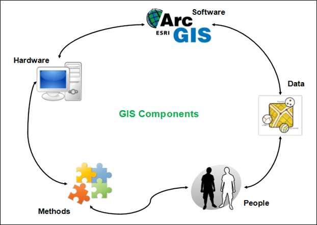
GIS operates on a computer system called hardware. A variety of computers are available these days, from desktop to server-based. The ArcGIS Server is server-based software that runs on a network or cloud-based computers.
In order for a computer to perform well, all of its components must have high capacities. Hardware components include the following:
Motherboard, Hard Drive, Processor, Graphics Card, Printer, and so on. Together, these components run the GIS software smoothly.
GIS software is the second component, providing the functions and tools necessary for storing, analyzing, and displaying geographical information.
Through it, users can query, edit, run, and display GIS data. It uses RDBMS (Relational Database Management System) to store data. Here are some GIS software names: ArcView 3.2, QGIS, SAGA GIS.
The most important component of a GIS (Geographical Information System) is the data. It is also known as Fuel for GIS.
It is possible to collect geographical data and related tabular data in-house, compile them according to custom specifications and requirements, or purchase them from a commercial data provider.
Spatial data can be integrated with other existing data resources, often stored in a corporate database management system.
A key function of GIS is the integration of spatial data (often proprietary to GIS), with tabular data stored in a database management system.
Geographic Information Systems are used by people. GIS software is run by them. As a result of extensive hardware and software development, people have been able to run GIS software without any difficulty.
Computers are also affordable, so people are using them for GIS tasks. Users can create simple maps or perform advanced analyses using GIS. People are the key to the success of GIS.
Business operation rules and a well-designed plan are important for successful GIS operations. Methods can vary with different organizations. Every organization has a documented process plan for GIS operations.
The documents cover a number of questions about GIS methods, including a number of GIS specialists required, GIS software and hardware, the process to store the data, and which DBMS (database management system) to use. A well-designed plan will cover all these issues.
Every day, thousands of organizations in virtually every field use GIS to create maps that facilitate communication, analysis, information sharing, and challenge solving. As a result, GIS is changing the way the world works.
Following are some examples of how GIS is used:-
By using GIS, geographic issues can be illuminated. When data is mapped well, geographic patterns emerge. You can see the patterns when you look at this map of opioid prescription claims.
People say a picture tells a thousand words, in the same way, a map tells a thousand pictures. It is helpful to geo researchers to monitor changes using GIS since the map data is displayed visually.
Geographic information systems provide real-time situational awareness. When natural disasters occur, GIS helps to control and respond to them.
GIS can be used to forecast traffic. The traffic forecast may indicate that over time the traffic will worsen or improve.
Based on spatial analysis, GIS helps to set priorities. For example, by analyzing crime patterns, public safety officials can identify target areas and assign officers in those areas.
GIS can be used to gain insight into data that might be missed in a spreadsheet. GIS makes it easy to understand trends.
Geographic information systems (GIS) combine geographic science with tools for understanding and collaborating. In doing so, it helps people achieve a common goal: to gain actionable intelligence from all types of data.
Using a GIS, you can capture, store, verify, and display data related to positions on the Earth’s surface.
A GIS can assist individuals and organizations with better understanding spatial patterns and relationships by relating seemingly unrelated data sets.
In this GIS course, you will learn what GIS and GPS are, you will gain knowledge and skills and you will be able to make better decisions. With GIS training, you will build a solid understanding of the software, as well as develop your analytical skills using GIS maps.
These courses are beneficial for the following reasons:
Many institutions offer GIS training. The question is, where can one enroll in GIS courses? Are there any best IT Training Institutes in Nepal?
Yes, in Nepal, School of Information Technologies is the best institute for GIS training. Enroll at the School of IT and enjoy your great career ahead.
The benefits of GIS training at the School of Information Technologies are:-
We recommend that you contact us as soon as possible since the number of trainees enrolling in GIS courses is growing significantly.
If you would like to reserve a seat at the upcoming GIS training, please contact us or leave a message on our inquiry form or social media page. We look forward to welcoming you to the School of Information Technologies.
GIS training does not require any specific prerequisites. However, if the individual is computer literate and capable of handling databases, it will be more reliable. Starting from the beginning, however, does not mean that one cannot do it.
Geographical boundaries matter a lot in any organization or industry; hence, the scope of GIS training is quite well expanded among corporate houses and entrepreneurs as this training allows them to implement the most advanced and latest technologies in order to make a positive impact.
In addition, it facilitates decision-making regarding geographical issues. In our country, we have abundant natural resources, so this training offers massive opportunities for resource management procedures that will help the candidates at the grassroots level.
As a GIS professional, your salary may vary depending on the location of your job, your title, and your experience. An intern or technician in a GIS position will generally earn at least $11/hour in a global market.
According to PayScale, the average salary for a GIS Analyst is $56,218.
Source: https://www.payscale.com/research/US/Job=Geographic_Information_Systems_(GIS)_Analyst/Salary
For students, the transition from college to the world of work is an important one, and it is not easy. As students enter the professional world, they face a variety of challenges.
The first step to establishing yourself in the professional world is to find the best internship for a Geographical Information System (GIS) Course in Nepal or abroad.
Students who enter the professional world usually begin with internships. They give them the skills they require beyond the classroom and the workplace, giving them an understanding of real-world problems and preparing them for their first job.
Do you want to do an internship but don’t know where to begin?
After reading this article you get a comprehensive guide on how to find an internship for a Geographical Information System (GIS) course in Nepal.
Internships are schemes offered by organizations to their employees, especially recent graduates or new graduates. For every student, an internship is a great opportunity. It can be part-time or full-time based on your needs.
The purpose of an internship is to enable students to apply their theoretical knowledge to the field in which they wish to pursue a career.
An internship is usually for a specified amount of time, depending on the field and workplace. Normally, it takes a few months to complete a GIS internship. An internship can be both unpaid or paid.
No matter what field you choose, an internship is not a prerequisite, but it adds skills above and beyond those learned in academic courses.
If you’re sure that you want to build a career in the Geographical Information System (GIS) then an internship is the ladder that leads you to a successful and well-paid position in the GIS sector.
There are literally endless opportunities in nearly every country globally as well as in nearly every professional industry. It’s all a matter of where & what interested you.
There are many ways for students, recent graduates, and freshers to find internships. I’ve listed a few ideas:
After GIS Training there are numerous job positions among them eight are listed below:-
As a GIS developer, you create and modify GIS tools, applications, programs, and software. In the last 10 years, this career has changed dramatically, moving from physical maps to digital maps in a cloud-based system.
A conservationist uses GIS mapping technology to analyze and identify natural habitats to preserve. This profession may place a lot of emphasis on fieldwork, depending on the workplace.
Law enforcement uses and analyzes GIS in many different ways to keep the city safe. GIS is an excellent tool for helicopter firefighters who track and locate fires on the ground to extinguish and police departments who analyze crime patterns using GIS.
In the field of cartography, there has been a great deal of development over time. The profession of cartography is still very relevant today since many maps cartographers create today have data embedded in them.
GIS tracking technology enables health geographers to analyze disease, disaster, and illness based on location and environment. In health geography, geographers track and prepare interventions to stop the spread of diseases.
Aircraft and satellite scans are used by remote sensing analysts to solve problems. People in these positions apply GIS to solve a variety of problems, such as those in natural resource management, urban planning, and homeland security.
GIS is used by climate scientists to analyze climate patterns and plan interventions. Research and action on issues such as global warming and natural hazards (earthquakes, volcanoes, hurricanes, tsunamis, etc.) are done by climate scientists.
GIS systems can provide information such as traffic patterns, weather patterns, crime rates, construction, school zones, highways, and hundreds of other details that can help planners effectively locate new businesses and homes, or create mitigation plans in the case of a disaster.
I hope now you have a better idea of what GIS training in Nepal entails and what career options are available. Overall, I must say that GIS training in Nepal is a very good career choice.
School of Information Technologies offers the best GIS training in Kathmandu Nepal. Join our training if you want to build your career in GIS. School of information technologies can help you to achieve your goal.
Also Read:- Best AutoCAD Training In Nepal